East of Backwell

Sustainable Integrated Community

December 2022

Welcome to Backwell

Images taken from the North Somerset Show photo gallery

A Sustainable Integrated Community
This brochure has been prepared by M7 Planning Limited in support of a highly unique opportunity to develop the vibrant ‘East Backwell Sustainable Integrated Community’ (EBSIC) in Backwell.
It provides a vision for a infrastructure led sustainable expansion comprising up to c.950 dwellings, a multi-modal link road from Station Road to the A370, transport hub/park and ride, land for a new wellness centre, a business centre, education facilities, retail provision, community hub and open space.
The masterplan is designed to be inclusive to all users and will encourage walking and cycling as the principal modes of transport. The future development is ideally located for the provision of safe and accessible routes of ‘green’ networks that will connect residential areas with areas of employment, education, shopping and leisure, thereby reducing carbon emissions and environmental impact.
This document recognises the importance of the ongoing Climate Emergency and the positive role future development should make. The proposal has been designed to facilitate a range of carbon neutralising measures which will be established as the project evolves. EBSIC has sustainability at it’s heart.
Our vision is exciting and ambitious to bring about positive housing and economic growth for future generations.


Location

Just 7 miles southwest of Bristol, on the A370 towards Weston-super-Mare, Backwell is a thriving settlement in North Somerset, England.
Backwell enjoys great transport facilities including buses to Bristol and access to the M5 motorway. Backwell also has its very own railway station (including direct to London Paddington and Cardiff) and easy access to nearby Bristol International Airport.
The project area is located to the east of Station Road, Nailsea and wraps around the northern and eastern parts of Backwell. Measuring approximately 61 hectares (150 acres), it comprises of a range of fields in agricultural use delineated by hedgerows.
The boundaries of the site are well defined, with the western boundaries abutting Backwell Secondary School, Backwell Leisure Centre,
a range of properties on the edge of the settlement and Station Road in respect of land to the north of the railway line. The eastern boundaries are formed by further agricultural land. To the south are existing residential properties and the A370, Farleigh Road.
The area is generally level, with a gradual fall towards the north west in the direction of Backwell Lake, a Wessex Water maintained balancing pond and nature reserve.
The land is within the Bristol Green Belt, which terminates on the easte


Current Access & Movement

Access is currently gained from various positions. The site benefits from main road frontage along Station Road, north of the Railway Station and facing the A370, broadly opposite Fairfield Way.
A number of Public Rights of Way cross the land, delineated by markers.
The site is bisected from east to west by the Exeter to Bristol main line, which is largely raised above ground level and creates a physical barrier between Nailsea and Backwell. The train line serves Nailsea and Backwell Railway Station, which is adjacent to the proposed northern access from Station Road.
Backwell Common partially bounds and bisects the site, which also provides vehicular access via an underbridge between the northern and southern parts of the project area.
Nailsea and Backwell Station is a well-used regional facility and recently underwent a car park expansion to accommodate the high level of demand from commuters. There are regular services to Bristol Temple Meads and London Paddington, amongst other locations.

Illustrative Masterplan

The Illustrative Masterplan shows the general character of land uses and the proposed structure of the development after completing a comprehensive assessment of the constraints.

01. Entrance from A370
02. Backwell School (Secondary)
03. Backwell Lake
04. Nailsea & Backwell Railway Station
05. New link road to relieve existing traffic burden along Station Road and to support Nailsea’s growth
06. Proposed new Local Centre
07. Land for a new Wellness Centre
08. Proposed Two Form Entry Primary School
09. Land opportunity for Retirement Village/Extracare Village
10. Potential new Park & Ride and Mobility Hub
11. Indicative opportunity for Sports/Playing Pitches
12. Indicative location of Attenuation Pond
13. Low rise Employment Use & Mobility Hub
14. Cycle route extension & connection to Festival Way
15. Coach parking & rear access to Backwell Secondary School, to facilitate safer access for the high volume of coach use by students across the wide catchment area
16. Link road entrance from A370
17. Link road entrance from Station Road

Future Access and Movement

Sustainable transportation is at the heart of the vision for EBSIC. We have ambitious aims to minimise the use of private vehicles and encourage sustainable travel options through the development of both new and enhanced existing infrastructure.
The new EBSIC Link Road (05), will begin at Station Road to the north of the train station via a new junction (17), which
will also provide access to a multimodal Mobility Hub, Business Park (13) and a Park and Ride facility (10). These facilities focus complimentary transport modes and uses, significantly enhancing transportation options to the wider area.
The Link Road will continue beneath the railway line towards the eastern edge of the project area, continuing southwards and finishing with a new junction on to the A370 (16).
The EBSIC Link Road, Mobility Hub and Park and Ride Facility are envisaged to be part funded by a localised Section 106 Contribution, levied upon all of the new allocations within Nailsea and Backwell.
The new housing will be close to the new areas of employment, amenities, schools, recreation and leisure facilities as part of a strategy to create a high degree of self-containment. This reduces the need to use the private car to travel, thereby reducing resource consumption and environmental impact, as well as increasing safety and accessibility for all.


The provision of green infrastructure corridors throughout the site will provide convenient pedestrian and cycle route networks resulting in a community that can navigate safely and freely around EBSIC.
The new Link Road will also serve as a vital extension of the Festival Way Cycle Route, with the construction of a new dedicated route linking from Backwell Bow to Station Road, via the mobility hub (14).
Via an improved entrance to Backwell Leisure Centre (01) the masterplan allows for a new rear access and coach park to Backwell Secondary School (15). This will assist reducing peak school time traffic flows along Station Road, which is currently inadequate and with no improvement capacity. EBSIC will help deliver a transport network which is both integrated with and significantly improves existing infrastructure. The project will create a platform for the growth envisaged over the plan period for Nailsea and Backwell, allowing them to thrive.
To promote the creation of a walkable place, a well-connected movement network has been established through connected green corridors. These will link existing areas of ecological interest and new habitats preserving and enhancing biodiversity and wildlife across the site. Ample green corridors will offer a wide range of spaces and activities such as parks with play and amenity areas which will contribute to a healthy community. 

These routes will be accessible to all helping ensure that EBSIC is easy to navigate, safe and secure.

Mobility Hubs

Mobility Hubs will be strategically positioned and incorporated as
a recognisable place, offering different and connected sustainable and active transport modes, supplemented with enhanced facilities and information features. Mobility hubs will be seen as the interface between the transport network and spatial structure of the area.
A main hub is proposed close to the train station, with a secondary hub located within the employment area to the east. These hubs will enhance the communities connectivity experience through the delivery of specific amenities such as EV car clubs and other shared e-mobility services, demand responsive transport, public transport connections, parcel lockers and last mile delivery services. These services can be interlinked with an app which will enable residents to book these services on-demand and manage their usage through the same account that they use to manage their energy service.

Housing & Delivery

The housing strategy seeks to re-dress the imbalance of housing stock in the area and enable community cohesion, by facilitating a wide range of dwellings to be accommodated from first time buyers to the elderly. The masterplan provides flexibility for higher density homes to be built close to the existing settlement and community facilities, DPH range = 40-50 dph (higher), filtering to lower density towards to the periphery, DPH range= 30-40 dph (lower).
Affordable housing is to be provided
in line with the new Local Plan policy requirements and through early discussions between North Somerset’s housing officers and our affordable housing partner.
Due to local demographics and transport accessibility, there is a good opportunity to provide a Retirement Village / Extra Care Village (09) as part of the project. Such facilities assist in providing more appropriate accommodation for the elderly, releasing family homes for re-occupation elsewhere.
The project has been deliberately designed to enable multiple phases, from multiple access points, to allow development to come forward efficiently, with the EBSIC Link Road being constructed in step with the development of the wider emerging allocations. A detailed phasing scheme will be required at application stage, which we envisage will allow for housing and infrastructure to be brought forward in line with local plan projections. We welcome early dialog with the Planning Policy Team in this regard.

Sustainability

Community Benefits

  • The development will positively contribute to the growth of the local economy by delivering new homes and employment opportunities.
  • 30% affordable housing to meet North Somerset Council requirements.
  • Walking connections to the local street network and improving the accessibility of existing public rights of way
  • New green infrastructure and public open space will provide amenity, with play facilities.
  • Retained hedgerows and trees creating a network of habitats corridors around walking routes.
  • A secured boundary of the site on all edges, with development fronting the open space.
  • Transitional open space with proposed clustered tree planting, hedgerow strengthening and species rich meadow grasslands.
  • Sustainable drainage attenuation features designed to create wetland habitats.
  • Section 106 contributions towards local improvements to services.
  • Community Infrastructure Levy payments.

Planning Application & Project Status

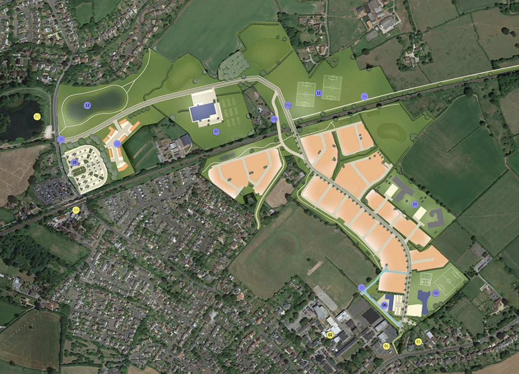
We are currently at the stage of preparing a Full Planning Application to submit to North Somerset Council. By submitting a ‘Full Planning Application’, we are seeking complete approval from the local planning authority for the design of our proposal (including the amount, scale, layout and appearance of the development, as well as any landscaping) and the proposed access arrangements.

Prior to submitting the application, we wish to engage with the community to understand local views and considerations that will positively assist in the formulation of our plans. Whether you are in favour of, or opposed to new housing on this site, please tell us why.

A summary of the feedback received through this consultation will be provided in a Statement of Community Involvement, which will form part of our planning application to North Somerset Council. 

Have your say

Form goes here